24 December 2022

It's Christmas ....

Jultomten

These old Christmas cards by the Swedish artist Jenny Nyström feature the Tomten and Julbocken (Yule Goat) of Nordic folklore. The little chaps are likely the origins of the Hobs and Brownies in Britain - so kindrid spirits of sorts.

 The Swedish scholar, Viktor Rydberg wrote a poem called 'Tomten' in 1881. Here it is recited in Swedish with English subtitles ...


As guardians of the home (Hus-tomten) perhaps we should raise a glass to these wee fellas, that they may never be forgot.


Image credits Jenny Nyström   http://jennynystromsbilder.kalmarlansmuseum.se/

20 December 2022

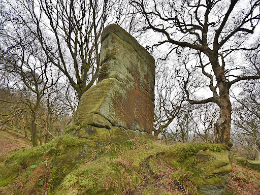
The Brimham Noon Stone - Pillar of the Sun

Noon Stone

 The Noon Stone is a 4 metre high rectangular block of stone standing on a low hill 1/4 of a mile to the south of Brimham Rocks, and 8 miles to the north west of Harrogate.

 Today the rock stands amongst trees planted on the hill side, but in the past it stood alone on the ridge, and formed a conspicuous local landmark.

 The travel writer Thomas Pennant visited the unusual rock formations at Brimham Rocks in the summer of 1777, and wrote ..."On my arrival on the summit of the hill, the seat of wonders, my astonishment was unspeakable ; the whole was new to me; a flat covered with stones of forms the most singular, and many of sizes most stupendous." (Pennant, 1804).

  After describing several of the oddly shaped outcrops in the main group, he noted ... "I finally take leave of these wonderous phenomena by saying, that opposite to a weaver's-house, beneath the crags, is a round small mount, on which is a rectangular natural stone, quite erect, and, at a distance, taken for a tower ; it is about thirteen feet broad, and about three feet thick. The country people call it the Noon-Stone as the meridian is made known to them by the shining of the sun on it."

30 November 2022

Freda of Wensleydale and the Fairy Well

 The Fairy Well is located in a field on the west side of Harmby village, 1 mile to the south-east of Leyburn in Wensleydale.

 A strong spring emerges on a grassy hillside in the field, with the water flowing into an old metal trough. Tumbled dry-stone walling partly surrounds the trough, while an old Hawthorn tree over hangs the well - a 'Fairy Thorn' perhaps ?

 We first visited the Fairy Well over 30 years ago with Edna Whelan and Ian Taylor, who were researching for their book Yorkshire Holy Wells and Sacred Springs (1989). This was in the days BC (before computers) when research involved reading books, visiting libraries, and contacting people for information. Edna had spoken to a local lady called Freda White who had grown up in Harmby, and knew the history and folklore of the well - even having written a song about it.

15 November 2022

Roseberry Topping - Odin vs Saint Oswald?

Roseberry Topping

 A previous post noted that the impressive peak of Roseberry Topping seems to have been regarded as a holy hill in the past.

 Anciently known as Othenesberg or Odin's Hill, this dedication, along with the possible lost shrine altars at Airy Holme, and a nearby placename suggesting a Danelaw Thing gathering location, could point to the hill being one of the main Anglo-Scandinavian religious sites in the region. The hill's dedication to Odin and the old religion, might also explain the later reference to a hermitage being located on the hill top. Perhaps the past history of the hill warranted the presence and prayers of a holy man, and yet a hermitage could also be seen as providing a continuity of religious practice on the hill.

31 October 2022

Return to Elbolton Hill - the Burial Cave

Elbolton Celia King
The Elbolton burials by artist Celia King

  A previous post highlighted the Faerie folklore connected with Elbolton Hill, near Grassington in the Yorkshire Dales. The hill is also significant in archaeological terms as it is the location of a Neolithic burial cave. The modern OS maps mark it as Elbolton Cave, but in the past it was called the Knave Knoll Cave. The local Dales accent must have baffled the OS map surveyors in the 1840's, who recorded it as "Navvy Noddle Hole".

 A visit in August 2021 found the entrance to the cave just below a limestone outcrop high up on the east side of the hill. Unfortunately there is a 8m vertical drop down into the actual burial cave, which means that today it is only really visited by cavers with climbing gear. This was a little frustrating as the excavation of the cave had revealed a group of rather unique burials, carbon dated to the early Neolithic (3900BC), and so it would have been interesting to look inside the cave.

16 October 2022

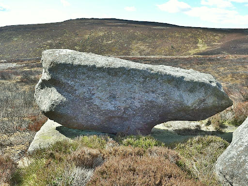
The Barden Fell Rocking Stone

Rocking stone Barden Fell
The Barden Fell Rocking Stone
 Barden Fell is an area of high moorland 2 miles to the north of Bolton Abbey, and 14 miles to the west of Harrogate.

 After the disappointment of finding the Thornthwaite rocking stone had been destroyed by Victorian quarrymen, a visit to Barden Fell also failed to identify the rocking stone marked there on the old OS map. A couple of large rocks at the location seemed likely candidates, but no amount of pushing and shoving could get either rock to move. On that occasion it was suspected that the rocking stone was the longer of the two rocks, and that it had been pushed off its pivot point. However, a return visit in October 2022 had more success, and identified the adjacent 3 metre long 'anvil' shaped boulder as the rocking stone (SE 08055 58520). Standing on top of this rock at its highest point, and using body weight, it was quite easy to set the boulder in motion. As with other rocking stones in this region the movement is not particularly dramatic - but this is still moving a rock weighing several tons. It is possible that pushing the 'nose' end of the rock may also set it moving, but this was not tried on that occasion.

30 September 2022

Somewhere a little different - the Lycian Way

simena tombs

Royal tombs in the hill top necropolis at Simena in southern Turkey, dating to around 500 bc. From these raised up sarcophagi, winged spirits carried souls to the afterlife.
The archaeological remains in this region really are a wonder to behold.

31 August 2022

Return to Hood Hill - another hill of Odin?

Hood Hill

  A previous post described the Altar Stone which used to stand on the top of Hood Hill near Sutton Bank, 5 miles to the east of Thirsk.

 Local folklore records that the large block of stone was originally a Druid altar, which was dropped on the hill by the Devil, but unfortunately the rock was totally destroyed in the 1950's when a jet aircraft crashed into it.

  In the early 1900's, Edmund Bogg noted another piece of folklore connected with the rock ...
“when the dinner-bell rang at Osgodby Hall the stone rolled down for its repast, and regularly returned to the crest after the meal.” (Bogg, 1906).

17 August 2022

Roseberry Topping - the high altar of Odin?


Beneath the shade the Northmen came,
Fix'd on each vale a Runic name,
Rear’d high their altar's rugged stone,
And gave their Gods the land they won.

Roseberry Topping

 The mountain like peak of Roseberry Topping is located 5 miles to the south east of Middlesborough, and forms part of the Cleveland Hills range running along the northern edge of the North York Moors.

 At over 1000 feet in height Roseberry can be classed as a mountain, and its distinctive shape has seen it referred to as the Yorkshire Matterhorn. Being such an imposing landmark, it is no surprise to find this hill features in the folklore, and even the ancient mythology of the region.

 When the hill starts to appear in land documents during the 12th century its name is recorded as Othenesburg, meaning 'Odin's Hill'. This name points to the early Anglo-Scandinavian settlers in this area having dedicated the mountain to their chief god Odin. Some confirmation of this being a holy hill may also come from the Airy-Holme placename, which is marked on the first edition OS map (1856) as a location on the east side of the hill, and half a mile to the north of Airy Holme farm.

30 July 2022

Airyholme - the Hovingham Horg?

Hollin Hill
Google Earth view of Hollin Hill and Airyholme farm - 2002


 Airyholme is located on the Howardian Hills, 1.5 miles to the south of Hovingham, and 6 miles west of Malton.

  "Airyholme with Howthorpe and Baxton Howe" is the rather long winded name of a township in the Hovingham parish. The township consists of just 4 farms, and its name appears to be derived from the ancient burial mounds in this area. In the early 1900's, the author Rev. Arthur St Clair Brooke described the Hovingham parish, and specifically mentions Airyholme ...
"Airyholme. This last is an interesting word. It is written Ergunholme in Domesday, and is derived from Horgum, plaural of Horg, old Norse for a sacrificial stone. The word is seen in transition in Dodsworth's Notes where it is written Arg-holme. Airyholme is therefore the holme near the sacrificial stones. Opposite the place, to the north, is a knoll of green grass, called Hollin Hill, on the side of which are some huge flat stones, the upper- most resting on a roller of old oak. They have all the appearance of having once formed a heathen altar, and the fine old oaks which grow on the hillside help to confirm the impression. " (Brooke,1904).

17 July 2022

The Devil's Stride - Roulston Scar

"Ye see, as our foore olders hev alous sed,
the giants yance wer maisters of all this hill country"

Devil's Stride Roulston Scar
The Devil's Stride - Roulston to Hood Hill

 A previous post peered into the Devil's Parlour Cave near Sutton Bank, 5 miles east of Thirsk. The cave is located in the rock face below Roulston Scar - an exposed section of high cliffs on the western edge of the Hambleton Hills. A wooded valley below the cliffs separates Roulston Scar from an outlying ridge called Hood Hill, with the gap between the cliff tops and Hood Hill being known as the Devil's Leap or the Devil's Stride.

  Writing in the mid 1800's, Thomas Gill noted that the Devil's Leap name came from a local story about the Devil flying from Roulston Scar and dropping a large rock on top of Hood Hill (see the Hood Hill Altar Stone page) (Gill, 1852). An alternative explanation for the name is said to be that the Devil once leapt or strode across the gap to show off his strength and abilities. These are not uncommon folklore themes, however there are hints that the legends may not have originally been about the Devil.

30 June 2022

The Hell Hole Rock - Crosper

Hell Hole Rock Crosper

 Crosper is located three miles to the south east of Harrogate.

 The Crosper place name survives today as Crosper Farm, on the road between Harrogate and the village of Spofforth. Crosper is thought to mean 'cross hill', perhaps from a cross having stood there in the past, although no cross exists today. In the fields around Crosper farm there are several large rock outcrops - part of the nearby Plumpton rocks group, which are thought to be the source of the Devil's Arrows standing stones at Boroughbridge, nine miles to the north. One of these outcrops on the east side of the farm is known as the Hell Hole rock, probably from the large cavity passing through one side of it.

 Harry Speight provides a description of the site in his Nidderdale book (Speight 1894) ...

18 June 2022

The lost Rocking Stone of Thornthwaite

Thornthwaite rocking stone map
1854 OS map  (Map credit NLS)

 Thornthwaite township is a scattered community spread along the Padside Beck valley, 8 miles to the west of Harrogate.

 The first edition OS map (1854) marks a Rocking Stone at Rowantree Crags on the high ground to the south west of Thornthwaite. The Rocking Stone does not appear on later edition maps, which ominously mark a quarry at the same location. However, overlaying the old OS map onto a modern satellite image seemed to show that a large rock still existed at the location marked for the Rocking Stone. Was it possible that the Rocking Stone had survived?

 Unfortunately, a visit to the site in Sept 2021 found no sign of the Rocking Stone, and very little sign of the Rowantree Crags, which appear to have been totally quarried away. The piece of rock visible on the satellite image turned out to be an exposed section of bed rock, which for some reason had not been quarried, and curiously, is very close to where the Rocking Stone was located. It is likely that the Rocking Stone sat on a similar section of rock within a few metres of this location.