Beneath the shade the Northmen came,
Fix'd on each vale a Runic
name,
Rear’d high their altar's rugged stone,
And gave their
Gods the land they won.
The mountain like peak of Roseberry Topping is located 5 miles to the south east of Middlesborough, and forms part of the Cleveland Hills range running along the northern edge of the North York Moors.
At over 1000 feet in height Roseberry can be classed as a mountain, and its distinctive shape has seen it referred to as the Yorkshire Matterhorn. Being such an imposing landmark, it is no surprise to find this hill features in the folklore, and even the ancient mythology of the region.
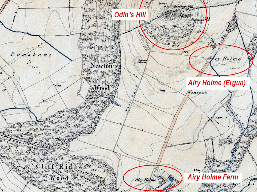
When the hill starts to appear in land documents during the 12th century its name is recorded as Othenesburg, meaning 'Odin's Hill'. This name points to the early Anglo-Scandinavian settlers in this area having dedicated the mountain to their chief god Odin. Some confirmation of this being a holy hill may also come from the Airy-Holme placename, which is marked on the first edition OS map (1856) as a location on the east side of the hill, and half a mile to the north of Airy Holme farm.

|
|
Roseberry Topping and Airy Holme - OS Map (1856) (Map credit NLS) |
The Airy Holme name appears in the Domesday Record as Ergun (or Ergum),
and the local antiquarian, the Rev J.C. Atkinson, linked this name to the
Norse word Horgum - meaning 'sacred altars'. He noted that "the Horg was an altar of stone erected on high places, or a sacrificial
cairn built in the open air". (Atkinson, 1882)
Old Norse texts mention that the Scandinavians
honoured their gods at their "Hofum ok Horgum" - temples and altars, while the
Anglo-Saxon word 'Hearg' had the same meaning.
Given that the Airy Holme (Ergun/Ergum) location is on the lower slopes
of Odin's Hill, if the Scandinavian settlers had a cult site anywhere in this
part of the Danelaw, then it would surely be at the hill dedicated to their
chief god.
Another Airyholme location can be found alongside
Hollin Hill near Hovingham
on the southern edge of the North York Moors. Here, the Rev A. Brooke
suggested that the Ergum name referred to several huge slabs of rock on the
side of the hill, which he suggested were ancient horg altars. (Brooke, 1904)
A rather more mundane interpretation derives Ergun from the Irish word Airge - meaning "a place where cows are, a dairy", with the later Airghe used for a hill pasture or a sheiling. At Roseberry Topping the area marked as Airy Holme could well be described as hill pasture, but so could much of the land around the farm, so why pinpoint one particular location alongside Odin's Hill? If the meaning was simply a dairy or cow pasture, then the Airyholme (Ergum) name should be far more common. This interpretation seems to overlook the Norse word Horg (and Anglo-Saxon Hearg), and import a word from another language group altogether.
That the Danelaw was well established in this region is also shown by
the records of several 'Thing' sites. These were the locations of regular
assemblies of free men, where matters of law, justice, and politics were
decided, - often at a place where religious rites took place. There are
records of a 'Thingwalla' near Whitby, and a Tinghowdale near Pinchthorpe,
while the Dingledow placename to the south west of Roseberry may point towards
Odin's hill also being a Ting site. The tall crag at Roseberry could be
compared to the Thingvellir in Iceland, where the rock face was used to
reflect the voice of the speaker towards the assembly.

|
|
'The Allthing' gathering at Þingvellir in Iceland - painting by W.G.
Collingwood 1890 |
Hofum ok Horgum - where art thou?
If the Ergun/Ergum placename did mark the location of horg altar shrines alongside Odin's Hill, then any evidence for them is long gone. Although the top of Roseberry is a huge mass of rock, the area around the hill no longer contains any significant boulders or outcrops. Quarrying, mining, and land clearance for agriculture, has removed all the rock in that area, and the extensive disturbance from these activities can still be seen. This land clearance was still going on in the early 1800's, as recorded by John Walker Ord in this interesting quote ...
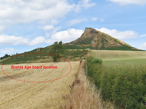
"Mr. Nicholson of Egglescliffe, In March 1826, as a labourer in the employ of George Jackson, Esq., of Taunton in Cleveland, was engaged in clearing away some blocks of stone on the south side of Rosebury Topping, about half-way up the hill south of the summer-house, he discovered a number of ancient implements lodged in a cleft of the rock, about a spade’s graft below the surface, many of them in high preservation, and others in a somewhat mutilated state." (Ord, 1846)
These implements were part of a Bronze Age hoard consisting of around 20 bronze items, including axe heads, knives and hammers etc, which had been deliberately placed in a crevice in the rock around 3000 years ago. Given the location, there is a possibility that this was an ancient votive deposit buried below the hill.
Interestingly, the location marked as Airy Holme on the old OS map was later chosen as the entrance to one of the iron stone mine workings. This mine followed a seam of the rock running close to the surface, and appears to have headed towards and possibly under Roseberry. It is also worth noting that the slope from Airy Holme up to Roseberry is one of the few places where surface stone and possible bedrock can still be seen amongst the hillside vegetation. In the past there may have been iron stone outcrops on the slope at Airy Holme (from the seam below), and the iron content would likely colour them the distinctive red-orange, as seen elsewhere in the area.
Again, Old Norse texts refer to the Horg altars stained red with the blood of offerings, so to find rocks naturally stained would have some significance, and perhaps mark them out as natural horgs. At the Airy Holme located alongside Hollin Hill near Hovingham there is a very prominent iron rich chalybeate stream running at the foot of the hill. This stream originates near a large burial mound, and its waters stain anything it flows over a bright ruddy orange colour.

|
|
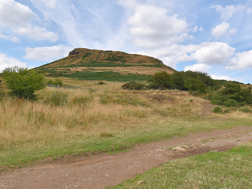
The Airy Holme area looking up to Odin's Hill |
As horgum is the plural of horg, the word points to more than one
shrine or altar. It is possible that the rocky summit of Odin's Hill was the
main cult site, with perhaps a more accessible horg (stone altar or cairn) on
the lower slopes at the Airy Holme (Ergum) location. This could have also been
a wayside shrine alongside an old route passing over the hills at this point,
possibly even a Bronze Age trackway, given the hoard buried near by.
The impressive peak of Roseberry topping appears to have long been regarded as a holy hill, perhaps even back into the Bronze Age. Any one standing on top of Roseberry today might easily recognise the Reverend Atkinson's description of the Horg as "an altar of stone raised on high places". It is certainly unlikely to find a more dramatic location to swear an oath or make an offering to the old gods than on the rocky summit of Odin's Hill.
After thoughts
The Ergun / Ergum sites at Hollin Hill and Roseberry, along with the Altar Stone on Hood Hill, might suggest that a chain of 'Horg hills' once existed around the edge of the moors. Other distinctively shaped hills or ridges such as Freebrough Hill, the Wainstones, and Whorl Hill might also have been part of this group.
References
Atkinson, J.C. (1882) A Handbook for Ancient Whitby and its Abbey.
Brooke,
Arthur St. Clair (1904). Slingsby and Slingsby Castle.
Ord, J.W. (1846) The History and Antiquities of Clevelan.


Post a Comment