

The Devil's Parlour cave is located in the cliff face at Roulston Scar, half a mile to the south of Sutton Bank, and 5 miles east of Thirsk.
The cave takes the form of a tall but narrow fissure in the rock face at
the base of the cliffs. The passage is not much more than two feet wide, and
extends about 30ft into the rock before it becomes impassable. There appears
to be nothing particularly 'devilish' about this cave, so how did it come by
its curious name? The answer would seem to lie in a local story which connects
Roulston Scar with the Devil, and the prominent ridge of Hood Hill, half a
mile to the west.
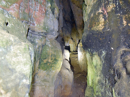
|
| View along the passage |
Thomas Gill appears to be the first to record the story during the mid
1800's, when he gave a brief outline of the tale in his
Vallis Eboracensis (Gill,1852). Although Gill does not mention the cave directly, its location at the foot of
Roulston Scar is the setting for the story, and so it seems likely that the
'Devil's Parlour' featured in the longer version known locally. Elsewhere on the
moors, John Fairfax Blakeborough records that these kind of traditional stories
could take many hours to recount in full by a story teller.
As Thomas Gill appears to be the first reference to this local story, it is
worth quoting ...
"The vale below, dividing Roulston crag from Hood Hill, is called "The
Happy Valley" but the intermediate distance is less auspiciously named
"The Devil's Leap." for which this reason is given by the village oracles.
The Happy Valley was a famous retreat of the ancient Druids, who without
molestation or disturbance had for centuries practised their incantations
upon the poor deluded inhabitants. When the first Christian missionaries
visited Yorkshire, they sought out the hidden retreats of Druidism, and
one of them had penetrated the Happy Valley, to the no small dismay of the
Druidical priest. The ancient Britons listened patiently to the statements
of the Christian missionary, weighed the evidences in their own minds, and
were perplexed as to their future procedure. In this dilemma, a conference
was appointed, in which the advocates of Druidism and Christianity were to
meet in public contest in order to decide which of the two systems had the
best claim to their worship and submission. The meeting as usual was
appointed in the open air, at the foot of Roulston Crag. The intellectual
assailants met, and the devil in the garb of a Druidical priest came with
the worshippers of Baal. The Evil One placed his foot on one of those
mountain rocks, and being foiled in his arguments by the powerful
reasoning of the missionary, flapped his brazen wings and fled across the
valley with the stone adhering to his foot, the heat of which (they say)
melted a hole in the top, until he came to the ridge of Hood Hill, where
he dropped the massive block, leaving the missionary the undisputed master
of the field.
This account will of course be received as a legend,
but it is matter of fact that a large stone weighing from sixteen to
twenty tons, of the same rock as Roulston Scar, is deposited on the ridge
of Hood Hill, bearing a mark on the top not unlike a large footprint. How
it came there is a matter of curious enquiry. It is evidently a work of
art, and most probably one of the cairn altars of the Druids, where they
burnt sacred fire and offered sacrifices to the sun."

Thomas Gill's rather 'Victorian-ised' overview of the story places the assembly at the 'foot' of Roulston Scar - perhaps because he knew the Devil's Parlour cave was located there, however the Devil's Leap name suggests that the events may have taken place on the top of Roulston Scar above the cave, as recorded in a later version of the story.
It is interesting to note that the Druids were the educated political and religious leaders of the tribal groups in Iron Age Britain, and it just so happens that there is an extensive Iron Age enclosure on the top of Roulston Scar, directly above the Devils Parlour cave. This promontory fort is one of the largest in Britain, and covers more than 60 acres, with ditch and bank earthworks enclosing the projecting headland at Roulston. The high cliffs of Roulston Scar run along the west side of the enclosure, and provide a magnificent viewpoint from which to survey the region, looking out across the vales to the south, west, and north. From the highest point within the enclosure there is an almost 360 degree view of the lowlands and the upland moors and valleys.

|
|
Roulston Scar Cave and Hood Hill (Map Credit NLS) |
The exact purpose of these hill top enclosures has not been established, but they appear to have been built to be visually impressive features in the landscape, along with the suggestion that they were used for large seasonal gatherings. The Roulston Scar hill fort is located within the Iron Age tribal area of the Brigantes people, so its large size may reflect the extent of their territory, and that it served a function for the whole tribal group. Although some of the long earthworks were visible in Thomas Gills day, the large enclosure itself had not been identified. This makes it interesting to consider that in the mid 1800's, Thomas Gill heard a story from local villagers about people gathering with their leaders and druids (iron age priests) at Roulston Scar - a scenario pretty much inline with the modern archaeological interpretation of the site.
During the Iron Age it is likely that ceremonial and ritual practices were among the activities which took place within the Roulston Scar promontory fort. From the enclosure it is possible to descend the cliff face and access the Devils Parlour, so the cave could have had some ritual significance. Elsewhere on the moors, these kind of 'Windypit' caves have been found to contain ritual deposits from the Romano British period. If some evidence or tradition for this kind of ritual use of the cave survived into the Christian era then an alternative explanation for the name could be that this was the cave of the 'devils' (ie. heathens).

|
|
View towards Hood Hill from the cave entrance |
The Devils Parlour is the only significant cave in the cliffs
below the enclosure. The cave entrance faces down the valley between the
cliffs and Hood Hill, and its position means that during the winter months,
the high cliffs block out the sun for most of the day, with it only appearing
briefly as it sets on the horizon framed by the valley. The Stellarium
Astronomy software indicates that at the winter solstice during the Iron Age
(400BC) the sun would set on the horizon at around 227 degrees from this
location. When viewed from the cave, the sun would only be visible for around
15 minutes as it appeared from behind the high rock face (to the south of the
cave) on its downward path to the mid winter sunset. Whether this phenomena
was observed in the past, or had any significance, will perhaps never be
known.
Numerous initials and dates carved into the cave walls show that the Devil's Parlour name did not put people off visiting the cave, even in past centuries when the religious fear of the Devil was much stronger. Some initials appear to be from the 1700's, and possibly one from the 1600's, with the style of lettering suggesting the dates are genuine. Quite a few of the markings are now barely readable, again suggesting some age, while groups of scratched lines might point to people who could not read or write wanting to leave their mark. It is also interesting to note that no carved initials were found in the Fairie's Parlour cave further north, which might be a sign of who the locals really feared?

After thoughts
In stories found elsewhere in the country, the Devil sometimes replaced
an earlier character when tales were 'updated' to reflect the popular beliefs
of the day. This may have been the case with the Roulston story, and there are
hints that the Devil may have replaced a giant, who was
the one actually responsible for the block of stone landing on top of Hood Hill. If this was
the case then the cave may have originally been known as the Giant's Parlour.
This would call for a tall but rather slim giant to fit in this cave, but this
same size contradiction was noted at the
Fairie's Parlour cave, where locals told Thomas Gill that it was used by giants in the past.
References
Gill, T. (1852) Vallis Eboracensis.
Post a Comment