21 December 2021

God Jul - Good Yule.


 These happy little fella's in a barn with a big bowl of creamy porridge are the Jultomten (Yule Tomten). A bowl of porridge was left out for them on Christmas eve in thanks for their help during the year.  The Tomten of Sweden and the Nisse of Denmark / Norway seem to be relatives of the Hobs of northern England, and probably share a common origin.

The Tomten were originally quite dark and aggressive figures protecting farms and dwellings, but they evolved during the late 1800's into much more jolly fellows delivering presents at Christmas. This transformation continued with one little chap becoming human sized and dressed all in red - the generic image of Santa Claus that we have today, while the original Tomten became Santa's little helpers.


These old Christmas cards by the artist Jenny Nyström capture some of the old Scandinavian Yule tide beliefs.


Wassail to all the good folk out there


Image credits Jenny Nyström   http://jennynystromsbilder.kalmarlansmuseum.se/


16 December 2021

Boggart Crag - Brimham Rocks

Boggart Crag Brimham
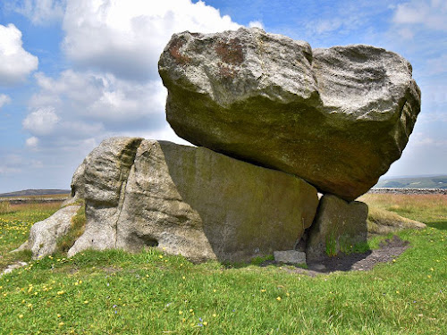
The 'Druid's Writing Desk' on the top of Boggart Crag


 Brimham Rocks are a large group of weathered crags and outcrops located near Pateley Bridge, 8 miles to the north-west of Harrogate.

 The rocks are spread across a wide hill top on Brimham Moor, which overlooks the Nidd valley to the south. A series of paths link the numerous crags, rock outcrops, and boulders stacks, which cover about 1 square km of the moorland heath on the hill. Some of the rocks have been shaped by nature to resemble various animals and objects, and these have been given names such as the Dancing Bear, Cannon Rocks, and the Yoke of Oxen, etc. Some of these names date back to at least the mid 1700's when the site began to attract visitors, and local guides started naming the rocks.

 A line of low cliffs and rock outcrops run along the western edge of the site, and towards its northern end, the first edition OS map (1854) marks one outcrop as the 'Boggart Crag'. The name does not appear on later maps, or in any of the guides to the site, which suggests that it was an earlier name used locally for that particular crag. The oddly shaped rock known as the Druid's Writing Desk is also located on the top of Boggart Crag, and this rock stands out on the horizon when viewed from the lower ground to the west. The stones prominent position on the skyline may have led to the belief that there was something uncanny about the misshapen rock and the crag that it stands on.

30 November 2021

Fairy Cave - Skirethorns

Fairy Cave - Skirethorns
  Skirethorns is a small hamlet, near Grassington, in the Yorkshire Dales.

 To the west of Skirethorns, a narrow lane winds its way up through Skirethorns Wood, and then through a gap in the limestone hills, to reach an area known as The Heights, with Malham Moor continuing further west. On the south side of the lane, a series of limestone scars rise up to form a low hill, which has a large cave opening on its west facing slopes. This is Height Cave or Fairy Cave, and was also known as Calf Hole. The wide entrance to the cave is divided by a limestone pillar, while at the back of the cave, a low passage extends into the hill. After 10m or so this passage becomes blocked with mud and silt, but it is thought to extend further into the hill, possibly connecting to other chambers and passages.

17 November 2021

Brandrith Crags Rocking Stone

Brandrith Crags


"Since bright the Druid's altars blazed,
And lurid shadows shed
On Almas Cliff and Brandrith Rocks,
Where human victims bled "

(Parkinson, 1882)


 Brandrith Crags are located on Hall Moor, 1 mile to the north-west of Blubberhouses, on the Harrogate to Skipton road (A59).

 The crags are split into 3 groups, and form an east-west line across the highest part of the moor. The eastern most group is the largest, and it is here that the modern OS map marks a rocking stone. Unfortunately, the map does not pinpoint the exact location of the rock on the crag, and it appears that people have searched for it without success. This suggests that the rocking stone either no longer exists or that it is not very prominent.

31 October 2021

Elbolton Hill - Hill of the Fairies

Elbolton Hill


"From Burnsall's tower the midnight hour
Had tolled, and its echo was still.
And the elfin band, from faerie land.
Was upon Elbolton hill."

(Dixon 1827)

 Elbolton is the name of a large dome shaped hill, 2 miles to the south of Grassington, in the Yorkshire Dales.

  Elbolton is the largest in a group of conspicuous hills located between the river Wharfe and the higher moorland of Rylstone Fell. These hills are referred to as the Cracoe Reef Knolls, as they are limestone outcrops that once formed part of an ancient sea bed. In the folklore of this region, Elbolton was regarded as the chief dwelling place of the fairy folk, and in more recent times archaeologists have found a group of Bronze Age burials in a cave on the east side of the hill.

13 October 2021

Rocking Stone - Rocking Moor, Thruscross

Rocking Stone - Rocking Moor

 Rocking Moor is an area of high moorland, three miles to the east of Bolton Abbey, and ten miles to the west of Harrogate

 The moor is named after a large rocking stone, which sits on top of an earth-fast boulder near the highest part of the moor. In most cases, rocking stones are natural features created by erosion, or when a boulder has been left fortuitously stranded during glacial times. The upper stones can weigh several tons, but if they only rest upon one or two pivot points, they can be finely balanced, and will move or 'rock' when pushed.

 Originally this rocking stone sat in isolation on the high moor, with panoramic views over the surrounding landscape. However, sometime during the 17th century a stone building was erected alongside the rocking stone, perhaps being used for hunting or other recreational purposes by the owners of the Bolton Abbey estate. The positioning of the building 'face on' to the rocking stone would seem to indicate that the stone was the focal point of the site, and that it had some local significance.

30 September 2021

Boggle hole - Robin Hood's Bay

Boggle hole - Robin Hood's Bay


"My mammy bid me gan to bed,
My daddy he said, No,’
My mammy said, if I wad na gan,
She would fetch the Boggle-Bo"


 Boggle Hole is a cave in the cliffs at Robin Hood's Bay, 5 miles to the south of Whitby. The cave has given its name to a YHA youth hostel, which was originally a water mill located in a narrow stream gully running down into the bay. Although the location is somewhat isolated, it is on a scenic and popular stretch of the coastline.

 The Boggle Hole cave itself is located in the cliffs immediately alongside the gully, on its south side. In the past the cave appears to have been larger, but at some point much of the roof has collapsed, leaving an open cleft running back into the cliff. The constant action of the tides, and winter storms are the likely cause of the collapse, undercutting the cave sides until they could not support the roof. In its original state the cave would have been similar to the Rev. Young's description of the Hob Hole cave at Runswick bay, further up the coast. (see Hob Hole post).

22 September 2021

This week i have been mostly swan Kulning .....


There are a few more posts about folklore sites in the pipeline, but i need to revisit the locations for photos. So in the mean time here is another curios and intriguing piece that caught my eye on youtube.

This kind of vocalising has a very ancient feel to it, and it can also be heard in the songs of  Karoliina Kantelinen (ethno musicologist at Helsinki university) who incorporates these old vocal traditions into her own performance.

30 August 2021

The Devil's Bridge - Hebden

The Devil's Bridge - Hebden
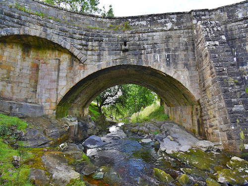
 The Devil's Bridge (Dibble's Bridge) spans the river Dibb near the village of Hebden, 3 miles to the east of Grassington, in the Yorkshire Dales.

 The old folklore of the area records that this bridge was built by the Devil, and a story based on this folklore appeared in the Chronicles and Stories of the Craven Dales (Dixon, 1880).

 The legend is set during the Middle Ages, sometime before the dissolution of the monasteries (1540), when Fountains Abbey was still a thriving religious community. A cobbler from the village of Thorpe (near Grassington) was returning home from the abbey with a bag of shoes for repair, when he found the river Dibb was in flood, and so he had to wade across. On the other side of the river he met a smartly dressed gentleman who asked him how far it was to Grassington. For some reason the cobbler was suspicious of the stranger and so he told him that it was a long way, and that he himself had worn out the bag of shoes travelling from there. The gentleman looked at the bag of different sized shoes, and raised an eyebrow,

13 August 2021

Nursa Knott and the Devil's Apronful - Appletreewick

Nursa Knott Hill (Nursery Knot on OS map)
 
 Nursa Knott (Nursery Knot) is a prominent limestone hill located two miles to the west of Greenhow village, near Pateley Bridge in the Yorkshire Dales.

  Nursa Knott features in a local legend about the Devil, and the story seems to have first been recorded by Bailey Harker in his Rambles in Upper Wharfedale (Harker, 1869). Harker's visit to Stump Cross Caverns required a change of cloths at the nearby Grouse Inn, where he noted ....

 "After we have dressed ourselves again in our own costume, we take the highway for Barden. To our right is Nursa Knott, and a little beyond it The Apron Full of Stones. Of these stones there is a curious legend, to the effect that the Devil being anxious to fill up Dibb Gill was carrying these ponderous crags in his apron when he stumbled over Nursa Knott, and the strings broke, the crags falling to the ground. It is said that if any of them were to be removed at night they would be carried back to their original place before morning."

27 July 2021

Trollers Gill - Appletreewick (The Barden Triangle)

Into the Valley of the Trolls
 
 Trollers Gill (also known as Trollerdale) is a narrow limestone gorge and stream valley located to the north of Appletreewick village, seven miles to north-east of Skipton.

 Beneath the hills to the north of Trollers Gill there is a large subterranean cave system known as Stump Cross Caverns. A stream emerges from those caves and flows down to Trollers Gill. When the stream (called Dry Gill) enters the north end of the ravine it once again sinks underground, leaving the stream bed dry below that point. This dry section continues down through the gorge to emerge at its southern end, where the waters then reappear amongst the rocks in the stream bed. From this point on the stream winds its way down the valley, passing Trollers Gill cave, and flowing on to eventually join the River Wharfe, a mile or so to the south. For most of the year the dry stream bed through the ravine is just a jumble of rocks and boulders, but after heavy rains the underground channel cannot carry all the water, so the stream forms a fast flowing torrent down the whole length of the gorge. This unusual phenomena, occurring within the atmospheric setting of the narrow gorge, is perhaps one reason why Trollers Gill has long been regarded as an 'uncanny' place.

4 July 2021

Hob Hole Cave - Runswick Bay

Engraving of Hob Hole Cave (Rev. Young, 1817)


 The Hob Holes are a group of small caves located in the cliff face half way along Runswick Bay, 6 miles to the north-west of Whitby.

 In folklore circles, the Hob Hole cave is famous for being the dwelling place of one of those short, dwarf-like beings known as a Hob. The first reference to the Runswick Hob appears to be in the early 1800's when the cave was described by the Rev. George Young in his History of Whitby (Young, 1817) ....

"Curious caverns are sometimes formed in the alum-rock by the operation of the tides. Hob-hole in Runswick bay once presented a most romantic appearance, the entrance being divided by a double pillar, as in the annexed drawing. This cave is still 70 feet long, and 20 feet wide at the entrance; but the pillar is now gone. "
"Another aerial being, which we may suppose to have been a hobgoblin, had his dwelling in Hob-hole, near Runswick. He was more benevolent than Jeanie; for his powers were exercised in curing young children of the hooping- cough. When any child in Runswick or the vicinity was under that disease, one of its parents carried it into the cave, and with loud voice thus invoked the demi-god of the place: “Hob-hole Hob! my bairn’s got kink-cough: take’t off; take’t off!” It is not very many years since this idolatrous practice was dropt."

25 June 2021

This week i have been mostly listening to ........

An ancient Finnish Lullaby  played on the Kantele by Merja Soria.

(Not sure why i like this, perhaps i have some Nordic roots? )

In the mythology of Finland,  the first Kantele was made by Wainamoinen - a primordial god of chants, poetry and song, who helped bring life to the world. When he played the kantele all creatures would come to listen to him.


 (By way of a change, and to complement the folklore posts, i am trying an occasional link to some of the things that have caught my eye on Youtube in the past. Hope they are of interest.)


10 June 2021

The Fairy Butter Tree - Scugdale

Looking down Scugdale


  Scugdale is a long valley cutting into the Cleveland Hills just to the South of Swainby village, ten miles to the south of Middlesbrough.

 The first edition OS map (1857) marks a 'Fairy Butter Tree' alongside Rank Crags at the head of the Scugdale valley. This curious name does not appear on later edition maps, so in order to get a grid reference for its location, the old map was overlaid as accurately as possible onto the newer OS map. This, combined with the Google Earth images, seemed to suggest that a tree still exists at that location (SE 52801 99357). Could it possibly be the same tree all these years later?

28 May 2021

Hob in the Hole and the Giant's Lapstone - Baysdale

 Hob Hole is located alongside a ford crossing Baysdale Beck, on the road between Kildale and Westerdale, five miles to the south of Guisborough.

 Up until the early 1800's, a large boulder known as the 'Giant's Lapstone' sat on the hillside overlooking the ford at Hob Hole. Around the year 1830, a great storm caused a landslip, which carried the boulder down the hillside and into the beck. The large rock must have come to rest close to the crossing, as it diverted the flow of water running over the ford. This led to the boulder being removed, which due to its size, had to be broken up.
(See this Youtube video of Gavin Parry and Bob Fischer at Hob Hole discussing the story behind the Lapstone boulder).

4 May 2021

Dannsa Na Cailleach - 'Dance of the Old Woman'

  A previous post (Cailleach an Dùdain) suggested that the North York Moors folklore figure known as the 'Old Wife', could well be related to the legendary Cailleach, who is to be found further north, in Scotland. Gavin Parry's ongoing project to map locations connected with this archetypal 'Old Woman' is both fascinating and illuminating, and shows just how widespread a figure she was.

 In later times, the Cailleach (Old Woman) seems to have played an important role in the harvest, with the last sheaf cut on a farm being called the Cailleach, which was then formed into a corn doll, and treated as an honoured guest at the harvest celebration. The corn doll figure was believed to contain the luck, fertility, and prosperity of the harvest, and was hung up in the farmhouse until the following year.

16 April 2021

The Ingleby Greenhow Wishing Stone?

 The village of Ingleby Greenhow is located at the foot of the Cleveland Hills on the northern edge of the North York Moors, 6 miles to the south of Guisborough.

The Hand of Glory by J. Fairfax-Blakeborough (1924) includes a story called 'The Maid of the Golden Shoon'. The original folk tale was noted down in the early 1800's from an old lady called Betty Ellis, who in turn heard it from her grandmother during the 1770's, when she was living at Ingleby Greenhow. This written version was later adapted and extended to create a Mell Supper play, and the manuscript eventually came into the possession of Richard Blakeborough in the 1890's, who then 'put together' the Maid of the Golden Shoon folk tale in its current form.

 Reading the story does suggest that an original piece of folklore has been adapted and extended to create a much longer drama, with a virtuous and moralistic conclusion. The first part of the story seems to be the older, more authentic section, with the stealing of several babies from their mothers side during the night, which is a well known fairy theme, but in this story it is a group of witches who are suspected. The local wise man is sent for, and in a dream his spirit is taken to a boulder known as the 'Wishing Stone', which is located on the moors above Ingleby Greenhow. Here, he witnesses the witches ceremony as they transform the babies into black cats to act as their familiar spirits. The wise man later instructs four men to visit the stone and perform a ceremony in order to learn from the fairies how to recover the missing children. From this point onwards the story takes on a more moralistic tone with the introduction of the 'Lady Winifreda', who seeks a virtuous knight to help her fight the witches - now transformed into dragons.

19 March 2021

Nanny Howe of Kildale

Court Moor and Nanny Howe - OS map  (1856)   Map credit NLS

The village of Kildale is located on the northern edge of the North York Moors, 4 miles to the south of Guisborough.

 Here's a question - is it possible for a burial mound to also be a person? This might seem rather odd, but at first glance this appears to have been the case at Kildale - at least according to the local folklore.

 The village sits in the river Leven valley, with the North York Moors stretching away to the south, and the Cleveland Hills forming the higher ground to the north. A narrow lane on the north side of the village leads up onto Coate Moor (originally Court Moor), with much of this hill top now covered by tree plantations. Before the forestry, there were three 'howes' or burial mounds standing approximately 45m apart on the eastern end of the ridge, with one of them being known as Nanny Howe. Frank Elgee (1933) visited the site in the early 1900's, and in addition to the burial mounds, he also noted stone walled enclosures and pits. Elgee also referred to the site's local name as 'the Devil's Court', from a tradition that witches used to gather there, and that Nanny Howe was named after a 'famous' local witch. In the regions dialect it was apparently not unusual for the possessive 's' to be dropped from a name, and so this is likely to have been 'Nanny's Howe'.

5 March 2021

The Fairies Parlour - Almscliffe Crags

Almscliffe Crags

 Almscliffe Crag is a large rock outcrop located on a low hill, 4 miles to the south west of Harrogate.

  The weathered mass of Millstone Grit sits at the southern end of a low ridge, elevating the crags into an even more prominent position, where they can be seen from many miles around. The top of the crags provide a 360° panoramic view, taking in the moors and surrounding farmland, and the valley of the river Wharfe to the south.

 It is perhaps no surprise to find that such a notable landmark would feature in the areas folklore, and in this case the crags were believed to be home to the local faerie folk. It is worth noting that these were not the dainty winged creatures of  Victorian imagination, rather they were believed to be supernatural beings, usually invisible to humans, but also able of assume any form when interacting with people. In the past there was a genuine fear of the faery race, as they were thought to be ever present, easily offended, and would cause death or bad luck to anyone who crossed them.

11 February 2021

The Old Wife of Danby Rigg

Old Wife's Stone - Danby Rigg
Old Wife's Stone - OW1 (NZ 71036 05926)

 
Danby Rigg is a large promontory hill on the northern edge of the North York Moors, 12 miles to the west of Whitby.

  The first edition OS map (1857) marks two stones on the east side of the hill as the "Old Wife's Stones". Today, a single large boulder remains on the site, while the fate of the second stone is unclear. Identifying the position of the missing stone is not helped by the 1892 edition map which marks the two stones in a slightly different position to the earlier map. Overlaying the maps on the modern aerial view also shows the mapping to be out by several metres - placing the stones a little to the south of the surviving Old Wife's stone (OW1). Re-aligning both maps on this stone provided two possible positions for the 'lost' second stone.

22 January 2021

The Giant's Grave - East Barnby

Wade's Stone - East Barnby

The hamlet of East Barnby is located four miles to the west of Whitby.

  A solitary standing stone known as Wade's Stone stands in a field to the north of the hamlet. Wade was a legendary giant who lived on the North York Moors, along with his wife Bell - who was also known as the 'Old Wife' in local folklore. The Standing stone is located on a low ridge which comes to a slightly raised and rounded end, 50m south of the stone. The stone itself is unusual in that it seems to have been a column of softer sandstone encased in 'Crow Stone' - a hard white flint (or Ganister), some of which still clings to the surface.

  The antiquary John Leland, writing in the late 1500's noted that ...

"Mougreve Castelle stondith on upon a craggy hille: and on each side of it is an hille far higher then that whereon the castelle stondith on. The north hille on the toppe of it hath certen stones communely caullid Waddes Grave, whom the people there say to have bene a gigant and owner of Mougreve."

14 January 2021

Buckingham's Stone - Bilsdale

Buckingham's Stone
Buckingham's Stone (2020)


 Buckingham's Stone is located in Tarn Hole - a large valley on the edge of East Bilsdale Moor, two miles to the south-east of Chop Gate on the North Yorks Moors. (See end note regarding access.)

 The stone is said to be named after George Villiers, the second Duke of Buckingham, who died at Kirbymoorside in 1687, shortly after hunting in this area. The duke was a flamboyant and controversial character in the royal court, but in later life he retired to Helmsley, and formed the Bilsdale Hunt. Officially he died of Pneumonia after catching a chill while out hunting, however a letter from his friend at that time (lord Arran) indicates that he actually died from an infection and gangrene in his 'private parts', after falling from his horse.