|
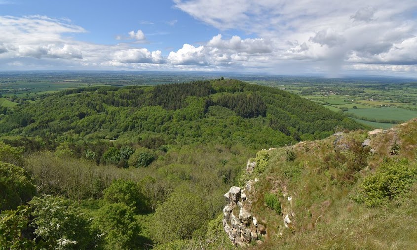
| Hood Hill (centre) and Roulston Scar (left) |
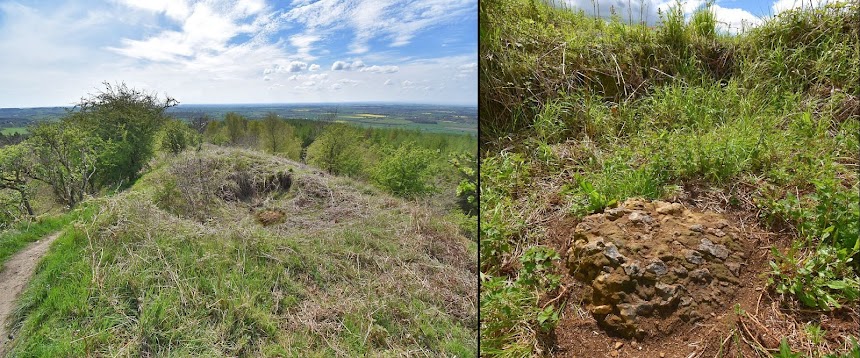
The 'Altar' was a large block of stone located on top of Hood Hill near Sutton Bank, 5 miles to the east of Thirsk.
Hood Hill is a prominent outlying hill separated off from the main Hambleton Hills escarpment. Up until the 1950's a large block of stone (known locally as The Altar) sat on the ridge of the hill, where it was described as being rectangular in shape, approximately 15 feet in length, 10ft wide, and 6 feet high. The Altar Stone is also said to have had a foot shaped cavity on top of the rock, and so it is perhaps no surprise that it was a local landmark, and also featured in the areas folklore.
Unfortunately the Altar rock was destroyed in 1954 when an RAF jet aircraft crashed into the hill during a training flight. The circumstances of the crash were something of a mystery at the time, as the jet seems to have nose dived vertically into the Altar Stone, totally destroying both the aircraft and the rock. The Altar Stone appears to have exploded into hundreds of small pieces, and today there is only a crater where it once sat, with a small piece of the rock in the bottom of the hole (SE 50376 81258).

|
| Site of the Altar Stone and a surviving piece of the rock |
The 'Altar' name connected the rock with a story told by local villagers to Thomas Gill in the mid 1800's, which he later included in his book Vallis Eboracencis (Gill, 1852). The villagers told Gill that the area around Hood Hill was anciently a stronghold of the Druids, and when the first Christian missionaries came to the region they challenged the Druids to debate the merits of their respective religions before the people of the district. The chief Druid spoke eloquently about the knowledge and traditions of Druidism, and how they had long served the people. The missionary then related the teachings of Jesus, and how he cleansed people of their sins, saving them from hell and damnation, along with the promise of eternal life. The assembled crowd nodded approvingly, little knowing that another interested party was present at the gathering in the form of the Devil who had disguised himself as one of the Druids. He had climbed up onto the Druids large altar rock to get a better view, and soon became incensed by the missionaries talk of saving souls. With his blood literally boiling, he let his disguise fall, and began to hurl curses at the Christians, as he attempted to fly away.
However, such was the heat generated by his anger, the rock beneath his feet had melted, and it was only with great difficulty that he able to take flight with the huge rock stuck to his foot. As he flew over Hood Hill he finally shook the rock loose, where it fell and landed on the hill top, standing there for over a 1000 years, with the foot shaped cavity on top of the rock as evidence of the events.
Thomas Gill placed the story in the 'Happy Valley', located between Hood Hill and the hilltop plateau of Roulston Scar just to the east. However, other versions of the story place the gathering on the top of Roulston Scar itself, and this ties in with the gap between Roulston and Hood Hill being known as the Devil's Leap or the Devil's Stride. Whatever the origins of the story, it is interesting to note that the Druids were the religious leaders of the Iron Age tribes in Britain, and it just so happens that the remains of an Iron Age hillfort exists on the top of Roulston Scar. It is also worth noting that the existence of the hillfort was unknown when Gill heard the story from the local villagers.

|
|
Rock cut foot mark at Dunadd in Scotland |
The presence of a foot shaped hollow on top of the Altar rock is
of interest, as there was also a foot shaped depression on the
Lapstone boulder in Baysdale. Sadly this rock has also been destroyed, but it is recorded that elaborate
fertility rituals took place on top of the rock. These foot marked rocks also
call to mind other examples found further north in Scotland, such as the one
at the Dunadd hillfort in Argyll, where a foot mark is carved into a rock
within the hilltop enclosure. It is thought that this site was used for the
inauguration ceremony of local kings, who placed their foot in the foot mark,
and swore an oath to protect the land and its people. Other foot marked
inauguration stones exist in Scotland, so there does appear to have been a
tradition of using such stones for this purpose, dating back to the Iron Age.
The Roulston Scar hillfort is one of the largest in Britain (enclosing over 60 acres) and it would have occupied quite a central location in the tribal territory of the Brigantes people during the Iron Age. The large size of the enclosure might reflect the extent of their territory, which stretched from Derbyshire up to the Scottish borders. The impressive nature of the Roulston promontory, along with its proximity to the main north south routes through the region, may have made it a suitable central gathering place for all the regional kings and clan chieftains who made up the Brigantes tribal group. Such gatherings of sub-kings and chieftains, along with their followers - their druids and warriors etc, would take place to decide on matters of law, politics and trade, along with ritual and ceremonial events.

|
|
OS Map
(map credit NLS) |
The promontory on which the Roulston Scar hillfort is located 'faces' out towards Hood Hill, which had the foot marked Altar Stone on top of it. It is tempting to speculate that this may have been one of the Brigantes royal hillforts - a place where their kings and queens were chosen and inaugurated. With a new leader selected by the assembled chieftains, they would ascend Hood Hill and mount the great Altar Stone, place their foot in the rock cut foot mark, and swear a royal oath, all witnessed by the gathered clans.
This can only be speculation, with the Altar Stone destroyed there is no evidence from the foot print rock itself, but anyone visiting the site of the Altar Stone on Hood Hill will be struck by the spectacular views from this location. Looking south there is an uninterrupted view over the Howardian Hills towards the City of York, and the lowlands stretching to the horizon 40 miles away. Turning west and north the expansive views continue across the fertile lands of the Vale of York and Mowbray, with the hills and valleys of the Yorkshire Dales and the Pennines rising beyond them.
For someone standing on the Altar Stone, it is unlikely that there is another location which provides a more impressive view of this region. As the newly inaugurated kings of Dal Riada looked out over their lands from the foot marked rock on top of Dunadd Hill, perhaps the royal leaders of Brigantia also looked out across their territory from the Altar Stone on top of Hood Hill. Standing on this ceremonial hill, with the great hillfort on the cliffs behind them - an impressive power centre of the Brigantes people - they would truly be rulers of all they survey.

|
|
The Devil's Stride - Roulston across to Hood Hill |
After thoughts
There does seem to have been a strangeness
about the large rock on top of Hood Hill, which became known as the Altar
Stone, linking it with the ancient Druids and the Devil, and possibly a giant
and old Odin himself. Even its destruction had something uncanny about it -
what are the odds of a jet aircraft precisely hitting that particular rock in
a vertical dive? The legendary origins of the Altar stone had it being flown
into position, while another flying object removed it forever.
The Roulston name perhaps invites some folk etymology. Roulston - Roul-stone - the rule or royal stone ? The words rule, ruler, royal, regal, etc all come from the same ancient root word.
Alongside the path 20m north of the Altar stone crater there is large piece of rock, but it is unclear if this is from the destroyed boulder. This rock has a 'knobbly' surface, and parts of the Altar Stone were described as having a similar surface, so it is of the same rock type. The soil around the crater is full of small pieces of stone, which can be seen in the paths either side of the crater. These would seem to be the shattered fragments of the Altar Stone.
The highest point of Hood Hill is partly encircled by a rock cut ditch, which
encloses a small area on the very top of the hill - creating a mini hilltop
enclosure. The date and purpose of this feature is unknown.
It is possible that the Roulston Scar hillfort was the eastern counterpart to the hillfort on top of Ingleborough, 48 miles to the west. There are similarities between these hill top enclosures (both had stone ramparts) and both are located in the central region of the Brigantes lands. Perhaps there was some east / west symbolism associated with the functions of each site? The OS map suggests that there is a line of sight between the two hill tops, maybe too far for the naked eye, but intervisible with fire beacons?
The Brigantes name is said to mean 'the high or elevated ones', and connects
them with both their tutelary goddess Briga, and high places. The name can be
traced back to a root word meaning 'to rise up' - perhaps pointing to the
sunrise and a dawn goddess of light?
Briga's People
In the high temples of Brigantia
Sacred fires burn day and night
Honouring each dawn
Mother of the sun
Giver of light


Post a Comment