

To the west of Skirethorns, a narrow lane winds its way up through
Skirethorns Wood, and then through a gap in the limestone hills, to reach an
area known as The Heights, with Malham Moor continuing further west. On the
south side of the lane, a series of limestone scars rise up to form a low
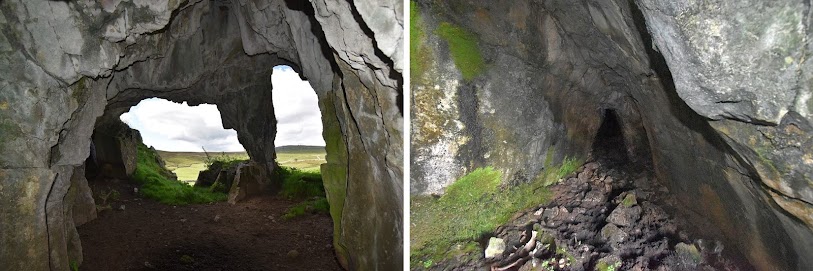
hill, which has a large cave opening on its west facing slopes. This is Height
Cave or Fairy Cave, and was also known as Calf Hole. The wide entrance to the
cave is divided by a limestone pillar, while at the back of the cave, a low
passage extends into the hill. After 10m or so this passage becomes blocked
with mud and silt, but it is thought to extend further into the hill, possibly
connecting to other chambers and passages.
|
|
Looking out from the cave, and the passage at the rear |
"On the opposite hill is another cave known as Fairy Cave or Calf Hole, in olden days a dwelling of fairies ; inside have been found small and curious pipes, called by the natives ' fairy pipes.' Aged people still tell how, in their youth, the fairies were often seen dancing in the bright moonlight, but time has even fled with the fairies, these harmless sprites of the moonlight have departed for ever; " (Bogg, 1904)
There are some similarities here with Elbolton Hill - with the fairies dancing at night, and the cave on the upper slopes of a rounded limestone hill, which might suggest a local pattern connecting such landscape features with the fairy folk. In the past there were probably other stories about the Skirethorns fairies, but they were not written down before they were lost.

|
| Looking up to the cave entrance |

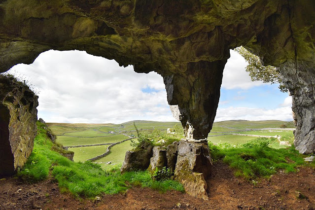
Climbing up to the hill top above the Fairy Cave reveals a large
plateau with low cliffs and areas of limestone pavement. The large blocks of
stone forming the cliffs suggest the walls of some hill top citadel, or in
other places, the tumbled remains of ancient buildings. On one part of the
hill the OS map does mark the remains of a settlement dating back to the
Iron Age, so perhaps all these features helped form the folklore that this
hill was a dwelling place of the fairies. The hilltop also provides an
extensive view of the surrounding area, with the rounded contours of
Elbolton Hill visible 3 miles away to the south east.

|
|
The green profile of Elbolton Hill in the distance (beneath the Thorn
tree) |
The local author Halliwell Sutcliffe took shelter in the Fairy Cave during a storm, while walking over Malham Moor. He found an old man already sheltering there, who told the author about a tradition that a queen of the ancient Britons had hidden herself in the cave, but no one knew why (Haliwell Sutcliffe, 1929). Again there is a possible echo of the Elbolton folklore where the hill and cave were home to the Queen of the Fairies.
The Fairy Cave was partly excavated in the late 1800's, when worked flints were found, along with an iron spear head (Jones, 1894). At a deeper level, a prehistoric tool made from antler was uncovered, and at the lowest level were the bones of animals such as bison, reindeer, and bear. The view from the cave looks out over Malham Moor and Higher Height Hill - the site of another ancient settlement. Just to the west of this settlement stand the remains of the 'Druid's Altar' - a large cairn with several standing stones. Although today this area feels rather remote, there are signs of people having lived amongst these limestone hills for several thousand years.
After thoughts
The cave and hill are actually on open access land, however the adjacent farmland to the west is not open access, and there are several private and keep out signs referring to this. To visit the hill and cave it is probably best to use the local public footpaths and bridleways to access the hill from its south side. On the hill itself there are several 'no footpath' signs painted on rocks, which is technically correct, if not a little miss leading, as there are no official footpaths over the hill, but they are not required when it is open access land. The signs may be the landowners attempt to prevent any rights of way being established in the future.
References
Bogg, E. (1904) Higher Wharfeland.
Halliwell Sutcliffe, (1929) The Striding Dale.
Jones, E (1894) Exploration of the Calf Hole Cave at the Heights,
Skirethorns, Report 64th Meeting Brit. Assoc. Advancement Science.
Post a Comment