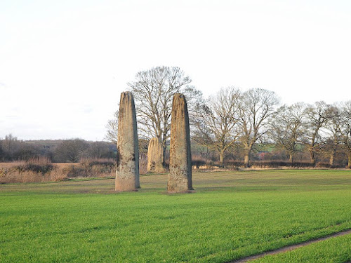
 The three large standing stones known as the Devil's Arrows stand in fields
to the west of Boroughbridge. When the antiquarian John Leland visited the
town around the year 1540, there was a fourth stone located next to the
central one. His description of the stones (from north to south) runs
....
"A little without this town on the west part of Watling Street standith 4 great maine stones wrought above in conum (tapering) by man’s hand. They be set in 3 several fields at this time. The first is a 20 foot by estimation in height, and 18 foot in cumpace. The stone toward the ground is sum-what square, and so up to the middle, and then wrought with certain rude boltells (fluting) in conum. But the very top is broken of 3 or 4 foot by estimation. The other 2 of like shape stand in another field a good bow shot off and the one of them is bigger than the other : and they stand within a 6 or 8 foot one of the other. The fourth standith in a several field a good stone cast from the other 2, and is bigger and higher than any of the other 3. I esteem it to the weight of a 5 wain loads or more."
Forty years after Leland, William Camden also visited Boroughbridge and saw the standing stones, but he noted that one of the stones had recently been toppled …
"Near unto this bridge Westward we saw in three diverse little fields four huge stones of pyramidal form, but very rudely wrought, set as it were in a straight and direct line. The two Pyramids in the middle, whereof the one was lately pulled down by some that hoped, though in vain, to find treasure, did almost touch one another. The outer most stand not far off, yet almost in equal distance from these on both sides"
William Stukeley saw the 3 remaining stones in 1725, and produced a detailed illustration of their setting (see below). His drawing shows that the stones were still located in 3 fields, as in Leland's and Camden's day, but there is nothing to indicate where the missing stone had been. Following Leland’s account that the two centre stones were in the same field and only 2m apart, later writers proposed that the missing stone could have been on the north side of the present centre stone. However, Stukeley’s drawing shows the centre stone with a hedge along its north side, so a stone in this position would have been in a different field. It also seems to have been assumed that the centre stones would both be in line with the north and south stones, but the remaining centre stone is noticeably offset from this line by several feet.
Stukeley’s drawing would seem to rule out the missing stone being to the north, but it may hold a clue to its original position. One feature that stands out on the drawing is the hedge line curving to the field corner on the far side of the centre stone. It would have perhaps been more practical to run this hedge to the actual standing stone so that it stood in the corner of the field, that is, unless the missing stone originally stood in that corner? This would explain the odd angle of the hedge as it curved to run behind that stone, leaving both the centre stones at the side of the same field. Being positioned in that corner would accommodate the 2 metre gap between the centre stones, and set them east and west of each other. This arrangement would also account for the present centre stone being offset to the west of the line between the north and south stones, while the missing stone would have been located a similar distance to the east of that line.
In 1736, Francis Drake of York published his 'Eboracum', which includes a plan of the 3 remaining Arrows. Drake was aware that there had been a fourth stone, but he does not appear to have had access to Leland’s full description detailing the stones central position. Instead he marked the site of the missing stone to the south of the present southern stone. This might suggest that Drake had local information which pointed to this also being the site of a removed stone. It might also provide some confirmation of the fifth Arrow, which was said to have 'anciently' stood in the row, and was mentioned by the vicar of Aldborough in the late 1600’s . The location marked on Drake’s plan is in an area called ‘Arrowfield’ on the old OS maps.
Prehistoric stone rows were built as a single row of stones, or a double row of parallel stones. A feature of the parallel stone rows is a broad ‘blocking’ stone placed at one end of the row. At the Devil’s Arrows the wide north stone would seem to fit this description, as noted by Aubrey Burl (1991). Burl suggests that stone rows evolved from the entrance stones and avenues leading into stone circles. At some point the stone rows were built without the circles, perhaps having come to symbolise the entrance to the circle and its function. The grand scale of the Devil's Arrows may have been a distillation of these symbolic elements, a stone row, with a pair of portal stones and a blocking stone. Only a geophysical survey of the area or excavation will reveal the true nature of this ancient site.


Post a Comment